
As you drive down Rt 40, across the Youghiogheny reservoir heading towards Maryland, you might not notice what lies underneath you. Somerfield became a town in 1818. It existed for over 100 years until the 1940's. In 1942 the Yough was dammed and the town of Somerfield was abandoned to make room for the newly forming lake. Every so often, the water levels recede and the old stone bridge that was the original Rt. 40 and derelict sidewalks of the town will show themselves. The first image courtesy of gribblenation.com, and the two non snowy pictures courtesy Vince Ferrari. The remainder are from a recent trip through the area.


A nice article about Somerfield is here.
The following pictures were sent to our FaceBook page by Jack Gates.......We thank him!


Some new shots from fall 2024 below:


I'm an interactive map! Play w/ me!
View Larger Map
A nice interactive map of the area now. Somerfield was located about 5 mm above the 40 sign on the map above. If you were to click on the "View Larger Map" link, a little orange/yellow guy should appear above the zoom controls and you can drag him to the above location for a 360 degree view of the non flooded area.
 |
| View from the middle of the current bridge, albeit 80 years ago. |


 |
| And todays view. (photo courtesy Vince Ferrari) |
 |
| The new Rt. 40 bridge crossing the Yough |


The old Rt. 40 approaching the bridge
 |
| Somerfield Bridge |


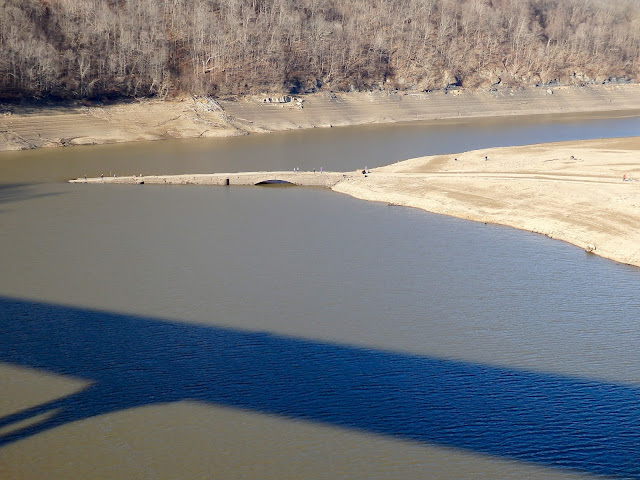
The new and the old. The stone bridge was once the longest bridge constructed on the original Rt. 40

 |
| Somerfield PA sidewalk |
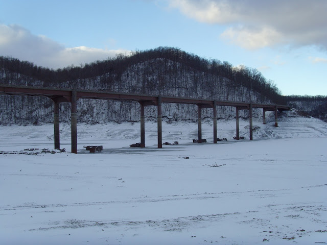
Snow covered sidewalks of the old town, whose blocks of old sidewalk can easily be seen under the right conditions.

A wide shot
 |
| November 19, 2015 |
 |
| November 19, 2015 |
 |
| November 19, 2015 |


A nice article about Somerfield is here.
 |
| Courtesy V. Ferrari. |
 |
| The bridge after towns demolition |
 |
| 1979 |


View Larger Map
A nice interactive map of the area now. Somerfield was located about 5 mm above the 40 sign on the map above. If you were to click on the "View Larger Map" link, a little orange/yellow guy should appear above the zoom controls and you can drag him to the above location for a 360 degree view of the non flooded area.
Amazing what is under some of these lakes, especially the ones out west. I know Cheat Lake supposedly has a cemetery under it..by the Stewartstown side.
ReplyDeleteI think a lot of these waterways have "cemeteries" beneath them. Not sure if it's an urban legend, or if some of them really are built over boneyards. I heard that some area around Somerfield was built on an Indian graveyard..... but then, kids love stories like that, real or imagined. :)
DeleteYou know, I vaguely remember hearing my grandmother and Mom talking about an Indian burial ground that was flooded.... I was so very young, and don't know if they mentioned a specific town. At that time, I didn't know anything about Somerfield, or even stories about Indians.... I just remember them talking, and Grandma saying that some people thought "ghosts" haunted the area because of the flooded cemetery. So.... maybe it's more than an urban legend. ;-D
DeleteNative Americans were here long before Europeans colonized this and surrounding areas. So, it would only be natural for there to be many burial grounds scattered throughout the region. I remember being told about the McKee's Rocks, PA burial mound when I was a child by my parents. Unfortunately, many burial mounds were probably undocumented and destroyed during the settlement and development of the region.
DeleteHowever, some have been documented,
https://pahistoricpreservation.com/spotlight-series-mckees-rocks-mound/
I was doing a store in Randleman NC a few years back and they were in the process of doing this same project around some farmland. Houses were razed, but most bridges and roads were left intact....I had my bicycle and traveled these roads....very quiet....I passed through there a few years back and it was all filled by then....I of course took no pictures.
ReplyDeleteVery cool! I knew there used to be a town there, but I didn't know the bridge was still there.
ReplyDeleteThanx, Jodi!
ReplyDeleteIts been a few weeks since I was there last and the water was down but I couldn't see anything (pictures from last winter). Usually this time of the year is best for viewing.
Thanks for posting these pictures and the abandoned turnpike post too. I grew up in California, PA and loved the stories my dad would tell me about the old towns and roads that had been bypassed.
ReplyDeleteYou are welcome! We enjoy doing this, makes people happy.
ReplyDeleteVery interesting topic. That bridge was one of the first (if not the first), and remains the only "intact" (to the best of my memory) triple arch stone bridge constructed on the original National Road. Still in pretty decent shape overall. Shame for all intensive purposes that it's been lost to history. It will continue to degrade with time. I did a Historic Property Management Plan for the Yough River Dam when I was in grad school, and was able to review some of the Corps reports on the town. Again, if I'm remembering correctly they basically just razed the town, so there's probably lots of artifacts still out there. Too bad they didn't relocate the bridge, because it's a beautiful piece of historic architecture and engineering.
ReplyDeleteI'm trying to find more information on Somerfield. I have relatives from there and I'm trying to figure out where they lived. Do you still have any of the Corps reports on the town or where I can find them? My great grandfather is from Somerfield.
DeleteI have to post this under anonymous as i don't have an account with any of the others, I posted what pictures I took either in 1991 or 1999, can't find a date on the pictures or in the album i have them in. It was a nice sunny day,,,,, hey are posted on my facebook page,,,under Laura Shipley Demchak or this link: https://www.facebook.com/laura.demchak/media_set?set=a.10152276586840259.1073741926.731565258&type=3
ReplyDeletecouldn't follow the link.
DeleteThe current boat ramps are the old road grade after the new bridge was built.
ReplyDeleteThis is magical for me to see, I never knew about this. Thank You very much!
ReplyDeleteNo problem, Joe! Glad you liked post!
DeleteDoes anyone happen to have any pictures of a schooL which may have been there? My dad's mother was a teacher there. I have always been curious and would love to show him a picture if possible.
ReplyDeleteThank You for the great history lesson.Yough Lake is down right now and the town bridge is visible.
ReplyDeleteThanks! Thanks for the heads up too! Stopped by today, and heading back Saturday!
DeleteThere used to be a picture, in one of the boat stores, by the lake. It showed someone water skiing under one of the openings of the old bridge!
ReplyDeleteMy folks migrated from Fairchance to the Meyersdale area in 1946. We traveled over the new bridge every other Sunday for some thirty five years. It always amazed me to watch the remains of Somerfield emerge from the Yough like a ghost at low water levels. What a gift to be able to look back and appreciate what once was and what will never be again! Thank you for gifting us with your pictures and work. I appreciated your effort very much as it emoked so many memories of those road trips back to visit Grandpa and Grammie!
ReplyDeleteCarolyn McKinney
Back in November 0f 1991, I think it was Thanksgiving W/E, the lake elevation level was 1,360'. All three arches were exposed. Being avid skiers, local native John Cornish said, lets put the john boat in, and ski underneath the old bridge! So we did! I believe we were the first ever to ski underneath the old stone bridge. The skiers, John Cornish, Jack VandeVisse, Carol Miller,and this writer, Gary Hileman.
ReplyDeleteI would be curious to know what the flow was like on the original Yough River. Looks like it drops over 100 feet in elevation in those miles under the lake. Anyone know if there were rapids or falls in that section? I know George Washington rafted the Yough River and took out somewhere below Confluence because of the rapids. Thanks, Rob
ReplyDeleteI WAS JUST THERE A FEW DAYS AGO AND WAS ABLE TO WALK REALLY FAR OUT ONTO LAND..TO THE EDGE OF THE OLD BRIDGE..STILL A TREE STUMP THERE AND BRICKS AND CONCRETE FROM THE ROAD/ SIDEWALKS...GREAT PICS...
ReplyDeleteI live right in uniontown pa grew up in german township where I stayed till my late 20s I'm 41 now and I have never ever heard there was a town under the tough until my boyfriend just told me. I think its awesome that our technology is so advanced that soneoen says oh yea their used to b a whole town under the yough and u can ask Google and it'll give u all the info out there and all the pictures its completely awesome.
ReplyDeleteI was born in Greensburg, but at least the 6 oldest kids in my father's family were born in Somerfield. My brother and I are at odds about my twin uncles, born in 1940. I think they were born there, and then the family was relocated to Confluence. He thinks they relocated, first, and then the twins were born. Sadly, there isn't much of the family left who would know. But that's always been one of my two favorite places in earth. I used to sit on the bank of the Yough, and watch the river waters roll by, imaging how life must have been when in 1818, when Somerfield was founded. Sad that it's become a tourist hub in recent years, ending all the wonderful imaginings of a young girl who always felt like I was "born a century too late."
DeleteI hope I can post this photo taken by Clyde "Jack" Pletcher of one of the Presbyterian summer camps in 1939:
ReplyDeleteSorry, I cannot insert the photo....
ReplyDeleteMy father used to tell me that when he was a young boy, his family had to move because they lost their home due to the flooding created by the dam. He never told me the name of the town. He may not have known, being 4 yrs old at the time. And I just found out that my 3rd great uncle, Bill Pullin, was the postmaster of Somerfield at some point. We would always go to the Yough dam when visiting my grand parents. Thank you so much for posting this information.
ReplyDelete