Yesterday, Chip and I headed out to scout some new locations and enjoy the mid 60 degree temperatures of the end of January. We hopped the ferry in Fredericktown and headed to the Fayette landing of the Crucible ferry. Chip had it in his head to climb the huge waste piles from the Crucible mine (yea, we know the dangers) and take some pictures. When we got there, via walking north up the railroad tracks, we quickly decided this sounded better in theory then in reality, so we put that entry point on the back burner for now.
 |
| Crucible mine slate dumps now |
And.......
 |
| Then...1938. |
It's weird. I've lived my whole adult life in Greene county, but know very little history from right across the river in Fayette county, and that was evident today as we walked the CSX tracks.
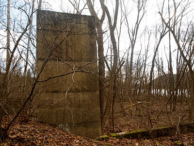
About a tenth of a mile north of the ferry landing we ran into these ruins....
A little further up the tracks we ran into this.....
The area in question is shown in this picture, taken in 1938. You can see the Crucible mine on the Greene side w/ all its barges and buildings, but in the questioned area, it doesn't look like there is a whole lot going on.
 |
| View of the old Crucible mine site from Fayette |


This comment has been removed by a blog administrator.
ReplyDeleteThis comment has been removed by a blog administrator.
ReplyDeleteSorry, the above comment was mean't for the Rices Landing blog which was above this one when you click on February blogs.
DeleteI believe the area you are asking about was a distillery. Probably in the early 1900's
ReplyDeletePaul Thompson.
Thanx for the idea, but I don't think it was that..I mean it could be, but I never heard of a distillery over there... I heard it was the remains of the old SWPA water plant, but I seem to doubt that too. I think it had something to do w/ the Crucible mine across the river....
DeleteMy Grandfather, C. Grimm, grew up in Crucible. Him and his father, David Grimm, worked at Crucible Mines.
ReplyDeleteMy grandfather had mentioned an old distillery as well, across the Mon. The feds shut down during the prohibition. But he said after that he said there were just a few houses on the Fayette Co. side of the ferry.
Interesting. Went back down there a few days ago. I still can't find any info on the old county maps, but those only go to the 1940's. Maybe it was closed then and not drawn on the maps.
DeleteI've long wondered about this, I've seen the concrete ruins and noticed the mine dump on satellite maps. My best GUESS comes from a book I have on the Monongahela Railroad. There was a town very near here that never was named Sara(h?). A patch town, company store, shaft mine and everything else was built, then. WHOOPS. We don't really have the mineral rights to this coal. So the railroad line there was abandoned, the town scrapped and razed. The coal is said to have "probably" been subsequently mined by the Hustead-Seamens company in East Millsboro, probably to be turned into coke for the steel industry. Awful long way to ship the waste if this came from any mine in East Millsboro or Isabella, but conveyor belts have been around a long time.
ReplyDeleteInteresting. I have heard of that towns name before, but thats about it. I need to research that. The piles close by the ruins came from across the river at the Crucible mines. Someone said this was some sort of water planet, but no one answered for certain. Thanks for your input!
DeleteI grew in Arensburg, in the sixties. We were always told that those ruins were the remnants of an old distillery. Chuck Kronk, who lived right above the ferry told us that.
DeleteAny chance of going to the courthouse and looking at the deeds? That usually tells a story!
ReplyDeleteHow did their slate dump come to be on the other side of the river? Did Crucible have a conveyor belt across the river? Did the mine go under the river? (I know of at least two mines that did, so it's possible).
ReplyDeleteAfter they filled up a lot of the space next to the mine, they strong a big cable across the river and basically filled in a gully. I think I have only seen one picture of this, and it's not very clear. But I have first-hand accounts of people when they were younger on the river remembering both the fairy and the cable car hauling the waste away
Delete